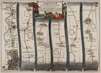
This extraordinary map, dating from 1675, details The Road From LONDON to the LANDS END Comencing at the Standard in Cornhill and Extending to Senan in Cornwall. It was made by IOHN OGILBY Esq[ui]r[e] his Ma[jes]ties Cosmographer and covers 308 miles and 3 furlongs (almost 500 km).
The atlas set the standard for using 1760 yards for the mile, and a scale of one inch to the mile. It contained a large number of strip road maps like these, which proved popular in planning journeys throughout the United Kingdom.
The life of John Ogilby (1600-1676) can be qualified without exaggeration as rather eventful... Διαβάστε τη συνέχεια (και πώς έγραφαν το Paddington τον 17ο αιώνα) εδώ, στο ιστολόγιο Strange Maps που φιλοξενεί ορισμένους από τους πιο περίεργους χάρτες του κόσμου.
Attachments
-
 ogilby.jpg99.9 KB · Views: 280